You cannot fully understand a place from the ground. Bern reveals itself differently at altitude — not grander, but honest. From the cockpit of a training aircraft, the city's medieval design becomes apparent in a way no map can show. The Aare makes sense. The mountains frame themselves. And every approach to runway 14 or 32 at Bern-Belp becomes less about procedure and more about geography made visible.
The Aare's Perfect Loop
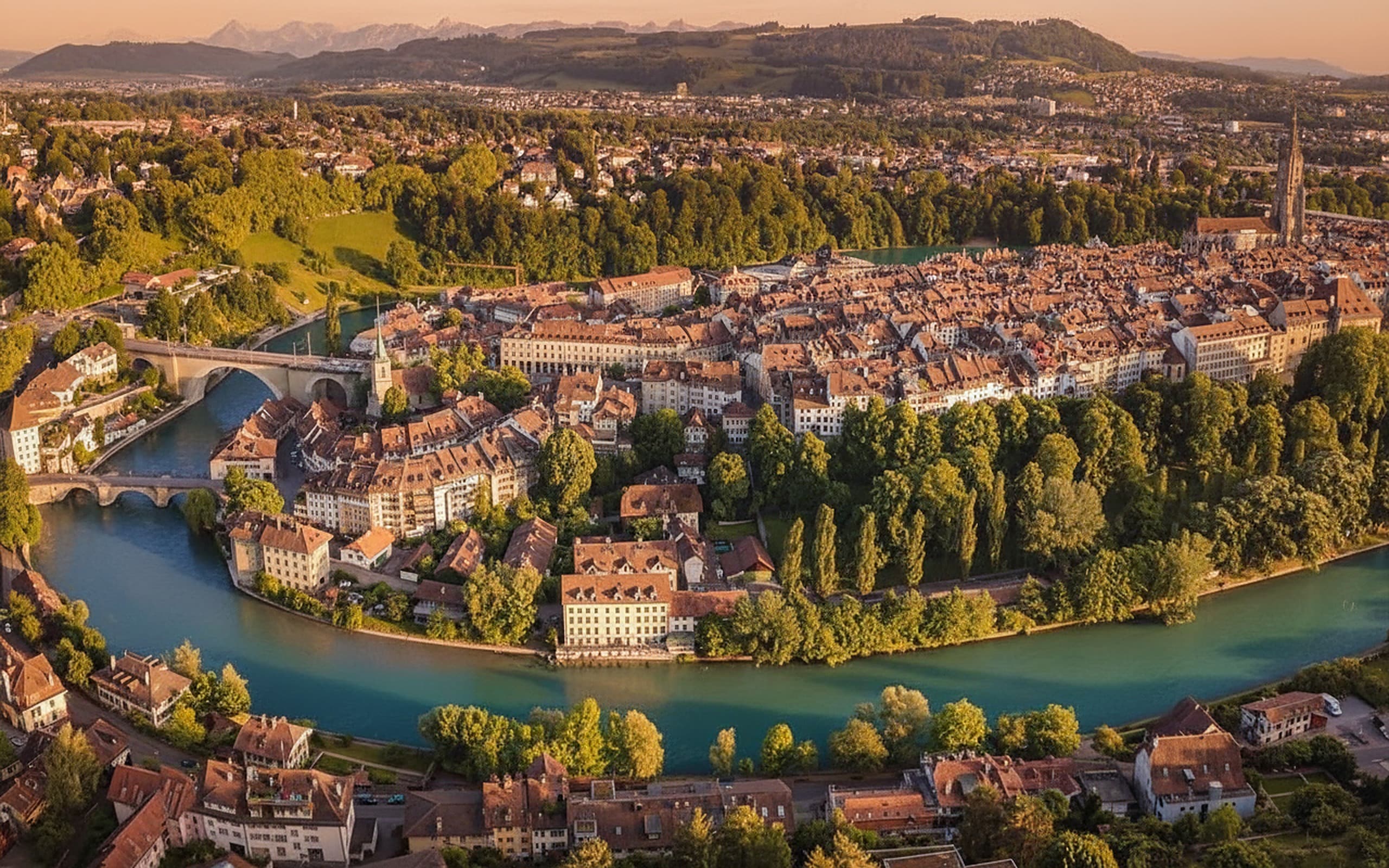
The first thing that strikes you is the Aare River. It does not flow straight. Near Bern, the river wraps the old town in a near-perfect omega — a peninsula so tightly enclosed that the river almost touches itself. From 2,000 feet, this geometry becomes stunning. The water catches light. The red clay rooftops sit inside this loop like a knot that the river has tied around them. This is not an accident. Medieval city planners chose this peninsula because it was defensible. The river does the work for them. Flying over it, you understand why in seconds.
Runway 14 Approach: Crossing from the North
When you are flying the 14 approach from the north — the most common training route — you cross the Aare about 3 miles from the runway. At that point, Bern is spread below and slightly to your left. The Münster spire — the Gothic needle that dominates the skyline from the street — becomes a simple reference point. It does not look tall from 1,500 feet. It looks like one vertical line among a grid. The real landmarks are the river bends, the arcs of the street layout, the roof patterns. ATC clears you down, and your descent angle naturally takes you across that omega loop and toward the runway. The checklist says configure, the map says descend, but your brain registers: that is where people live.
Runway 32 Approach: Flying Toward the Alps
Runway 32 is different. You come from the south, from the direction of the Alps. Bern sits in front of you, and behind it — if the weather is clear — the mountains rise. The Gürbetal valley opens up beneath you as you descend. This is alpine flying without the drama. You are in a training aircraft, following procedures, but the terrain around you is undeniably mountainous. The approach funnel narrows as you descend: 5,000 feet, the whole canton is visible; 3,000 feet, the Emmental geography makes sense; 2,000 feet, Bern dominates again. The runway is at the edge of the city. One turn onto final, and mountains are behind you. It is a routine training approach with an uncommonly beautiful backdrop.
Altitude Layers: What You See at Different Heights
Each thousand feet of altitude reveals different information. At 8,000 feet on a clear day — often the top of your training circuits — the entire chain of major peaks is visible. The Eiger, Mönch, and Jungfrau sit along the horizon. Closer in, the Stockhorn and Niesen define the skyline. The Gurten, the hill just north of Bern, looks like a modest bump. You can identify it only by its position. At 5,000 feet, the canton becomes obvious. Zurich is sometimes visible to the northeast. Geneva is beyond the horizon to the west, but the Lac Léman shows on clear days. Bern becomes a distinct urban centre — not yet detailed, but clearly a city. At 3,000 feet, the Aare makes sense. The bridges, the street pattern, the boundaries of the old town all align into coherent geography. At 2,000 feet, individual buildings matter. The Münster appears. The station. The major parks. This is where a city becomes a place. At 1,500 feet — approach altitude — you are inside the landscape. The runway runway dominates. The city is context. The mountains are reminders.
The Federal Palace and Landmarks
From above, the Federal Palace is not impressive because of scale. It is impressive because of geometry. The dome catches light. The arcaded courtyards are visible as patterns in the layout. The building sits at the eastern edge of the old town, and its position makes sense only from the air — it commands views across the full city and toward the mountains. This is not accident either. Swiss government architects understood their geography. The Münster spire, visible from almost any altitude above 2,000 feet, becomes your reference point for city orientation. Two bridges dominate the Aare crossing — the Nydegg and the Käfigturm — both visible as distinct structures once you know what to look for. These are not scenic ornaments. They are navigation features. Your instructors will teach you to use them. Ten approaches from different altitudes, and you will spot them without looking for them.
Seasonal Transformations
Bern changes with the season, and the air is where you notice it most. In autumn, the Aare valley turns gold — not photogenic marketing gold, but the honest amber of rapeseed and larch. The river stands out even more against the yellowing landscape. Winter brings snow to the rooftops, and the clay-tile red becomes a dramatic accent against white. The mountains, already visible, become sharper — colder air provides better visibility, and the sun angle sharpens shadows. Early spring is green-gray, the snow line creeping higher on the mountains daily. By summer, the entire Emmental basin is crop green, and the river is lower, the water a thin line threading through the landscape. None of this is spectacle. It is just what the land looks like. Flying the same approach route in April and October, you are looking at different geographies entirely — same coordinates, completely different landscape.
Reading the Mountains from the Cockpit
The Alps form a solid wall from most vantage points in Bern. From the air, they become readable. The Eiger is identifiable by its north face — a distinctive wall visible even in haze. The Mönch sits next to it, slightly lower and smoother. The Jungfrau dominates the chain. Closer, the Stockhorn appears as a modest peak with a distinctive summit — easily identified once you know it. The Niesen is almost as tall but looks steeper because it rises more directly from the valleys below. The Gurten is the exception — it is not a mountain by any standard outside Switzerland. It is a local hill. But its position north of Bern makes it instantly recognisable as a training reference. Learning to identify these landmarks is not optional. Your instructor will ask you to point them out. Other aircraft will reference them in position reports. Within a few training months, you will spot the Eiger on approach automatically, without conscious thought. It becomes as normal as knowing the runway number.
Night Approaches: The City Lights Reveal Pattern
Bern at night from the air is different than Bern by day. The city lights show its structure. The old town becomes a concentrated glow — all those medieval streets compressed into a bright knot. The Federal Palace is lit, often visible from altitude. The Münster spire sometimes carries light. The river, invisible in darkness, is occasionally revealed by reflections. The Gurten to the north forms a dark mass against the city glow — useful as a positional reference when the weather is dark. On clear nights with a good moon, the mountains are silhouettes behind the city lights. Flying a night approach to Bern in clear conditions is like flying a checklist above a map that has come to life. The city layout that was invisible during the day is suddenly the easiest navigation reference. Altitude means nothing at night — you follow the lights down to the runway. The city shows you exactly where it is and guides you to the landing.
Why This Matters for Your Training
Flying circuits at Bern, you will make the same approaches dozens of times. Some schools, this becomes procedural and numb. Here, it does not have to be. Every circuit is slightly different — different cloud base, different wind direction, different light quality. The geography beneath you is fixed, but the way you see it changes. Your first approach from the south is unfamiliar. By your tenth, it is routine. By your fiftieth, the Aare loop and the mountain horizon are as normal as your home airport. But then something shifts. The routine becomes familiar, and the familiar becomes beautiful. You are no longer learning the approach — you are living it. Bern from the air becomes a place you know, not just a location you have learned. This is the privilege of flying from a mountain airfield. You do not get numb to the view because the view is genuinely interesting. The city is genuinely beautiful. The geography is genuinely complex. And every landing means you have earned the right to see it one more time.
Photographing Bern from the Cockpit
If you want to capture Bern from the air, a few principles help. Shoot on approach descent, not in the circuit pattern — you have better altitude and distance from the runway. The best light is morning (sun from the east, lighting the Federal Palace and the old town) or early evening (sun from the west, shadows in the valleys). Avoid midday when the sun is overhead and shadows are minimal. The Aare loop is most striking when the river is high and the water is dark — April through June. Autumn brings the golden landscape, but haze is more common. Winter's clarity is excellent, but the low sun angle can be harsh. Use a window with no reflections. A circular polariser cuts haze. Shoot fast film or high ISO — the cockpit is shadowed relative to the bright landscape outside. The Eiger chain is easiest to photograph on the south approach when it is in front of you. The Gurten silhouette works best at dawn or dusk when it is backlit. And remember: your first responsibility is flying the aircraft. The camera is secondary. Most of the best Bern photographs happen when you stop trying to take them and just look.
Experience It Yourself
Bern from the air is stunning. But it is also just part of what flying from a Swiss airfield offers. The training is rigorous. The safety culture is uncompromising. The instructors are professionals. And the backdrop — the Alps, the valleys, the geography — never gets old. If you want to earn your licence somewhere that challenges and inspires you, alpaviation is waiting.
Start your training